
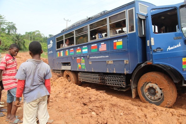
Stuck up to the back axle
It’s been several days since we had internet but there has been plenty to keep us busy. We camped for two days at Brenu Beach on the Cape Coast. We visited two depressing but enlightening ‘castles’ from which slaves were sent to the Americas. Then more camping at Kakum, a national park in Ghana.
And this being an overland trip, of course we got stuck. On our previous African overland, we spent a lot of time stuck in the sands of the Sahara Desert, but yesterday’s sticky situation was in the mud.
There’s been torrential rain around us—you can tell by the puddles—but we’ve only had sprinklings of rain.
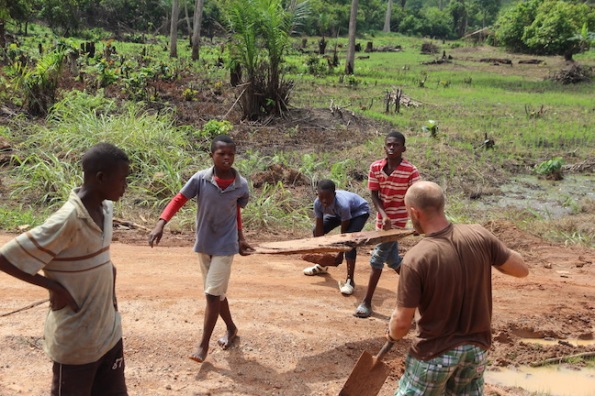
A bit of wood might help with traction
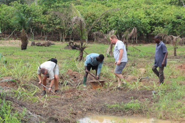
Gathering rocks and gravel to put in front of the tyres
Luckily we weren’t stranded for long. A joint effort including the driver, Jason, some fellow passengers and some helpful locals had us on the way in about 15 minutes.
Now that it’s caked in mud, the truck looks like a real overland vehicle.
P.S. I’ll write about the other stops soon. Just give me some internet. I’ve been trying to post this short item since last night. Too many error messages. On the upside, we had our first hot showers in nine days. We’ve had showers, but only cold.
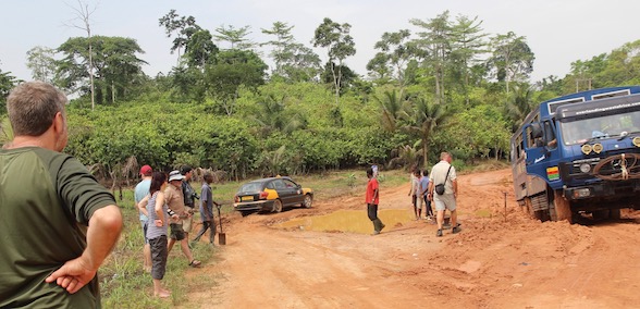
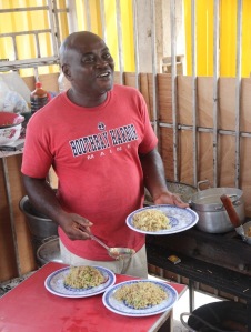
A taxi skirts around a puddle. We skirted on the other side

Larry and his assistant (didn’t get her name) at work in the kitchen
One of the most followed pages on my cooking blog is the recipe for fried rice (Ghana). It was part of a Ghanaian feast that we made a few years ago using cookbooks purchased in that country. The main picture on that post has been saved to countless Pinterest accounts, as well as many website promoting Ghanaian food and produce.
Poor John and I are back in Ghana for the start of our next overland adventure. We’re in Accra (the capital) for a couple of days to meet the group and get some visas.
Of course, sightseeing has to be part of the stay. So yesterday three of us grabbed a taxi to Teshie to see the amazing carved coffins that make that suburb famous. Of course, when we got there about 2pm, our stomachs reminded us that we hadn’t eaten lunch.
We stopped at a likely looking hole-in-the-wall, but they had finished serving lunch. The next hole-in the-wall sold only alcohol and the third was a sports bar with loud music and a raucous crowd.

Ghana is quite religious and it shows in their signage
But then Dee and I spied the Ingot Hotel and its simple restaurant out the front. We inched our way across the busy road and popped in to see if lunch was an option. Larry, the cook, suggested fried rice, and Dee asked if it could be ‘with egg on top’. Sure thing.
So we settled down with a couple of beers and a pear soft drink. The room next to us was filled with people. It was decorated in red and grey, with small pews and a lectern. At first we thought it was a small church, but it turned out to be the hotel school.
Larry dishes up our lunch
A couple of young women came and asked if they could have their photos taken with us. It became quite a production. All the students and teachers spilled into the hotel courtyard, and countless photographs were taken. We looked pretty scruffy compared to them, but they insisted that they are going to put our group photo on the hotel’s advertising banner.
So if you’re ever on the main street in Teshie, be sure to look our for our picture.
P.S. Another post soon about the coffins. The internet connections have been dreadful and it’s taken me 24 hours to get this posted.


The making of a hotel banner. Poor John looking especially scruffy

Hope you’ll forgive my intermittent absences over the next eight weeks. Poor John and I are off on another adventure. I’m writing from Singapore on the way to Accra, Ghana.
A map of the basic overland itinerary is above, although Burkino Faso has recently been omitted because of escalating unrest there.
Here’s a link to the initial trip. This is the second time we’ve travelled in West Africa on the back of a truck. In case, you’re wondering, we’ll be camping again. My backpack, including roll mat and sleeping bag, weighs 12 kilos. Poor John’s weighs 14, but he’s carrying the laundry and coffee supplies.
The second leg of the trip—Freetown to Dakar—was full, so we’ll cover some of that distance by taxi and a flight.
No idea how much internet I’ll have, so I apologise in advance for all the posts I won’t have a chance to like or comment on. I’ll try to post as often as possible. Life will be back to ‘normal’ toward the end of April.
The map below gives you an idea of just how huge Africa is compared to the rest of the world. We’ll be travelling along the part overlaid by some of the map of the United States.

Size of Africa compared to the rest of the world

This gives you an idea of the size of the stumps
Part of the tourist trail at the Florissant Fossil Beds
So many people—friends and strangers—urged us to visit the Florissant Fossil Beds National Monument that we absolutely had to go. We’re so glad we did.
This prehistoric park, located in central Colorado, is home to mountain meadows and rolling hills forested with ponderosa pines, spruce, fir and aspen. But these trees stand in stark contrast to the park’s main attractions—petrified giant sequoia stumps, as well as delicate insect and leaf fossils.
The stumps are all that’s left of redwoods that were up to 13 feet (4 metres) wide and more than 250 feet (76 metres) tall.

Florissant finally protected in 1969

Florissant promoted as a tourist destination
I was shocked to learn that it took 50 years of advocacy by scientists and others to get the fossil beds officially protected in 1969. Before then, the stumps were a novel tourist attraction with relic hunters trying to saw off moveable pieces.

Remnants of a stump lost to relic hunters
Plus, the loss of fossils was tremendous. Florissant pieces have been carted off to more than 20 US and UK museums and universities. Harvard University alone has 8000 fossil insects collected by paleontologist Samuel Scudder in the late 1800s.
In recent times, park staff inventoried and photographed more than 5000 significant fossils at 17 museums. From this, they have created a virtual museum and research database that can be viewed here.


We spent quite a while in the visitor centre, looking at their collection of fossils and listening to a retired geologist explain some of Florissant’s importance.
The monument has yielded more than 50,000 museum specimens, from more than 1700 species. They include 1500 insects, 150 plants, and one of the world’s only known fossil records of the tsetse fly, which now occurs only in equatorial Africa. It also has fossils of more known species of butterfly that any other site in the world.


After the visitor centre, we walked part of Florissant’s 14 miles of trails. It’s something you need to do at a leisurely pace. The sun is hot, there’s not a lot of shade cover and the altitude is 8500 feet above sea level.
We loved this stop and I can highly recommend adding it to your travel plans. The community of Florissant was especially good to us too, but I’ll write more about that later.
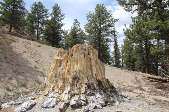
Relic hunters attacked this stump

Close up of the stump above

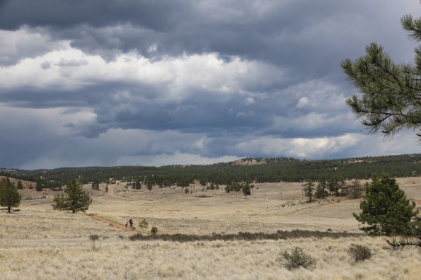
The landscape at Florissant Fossil Beds
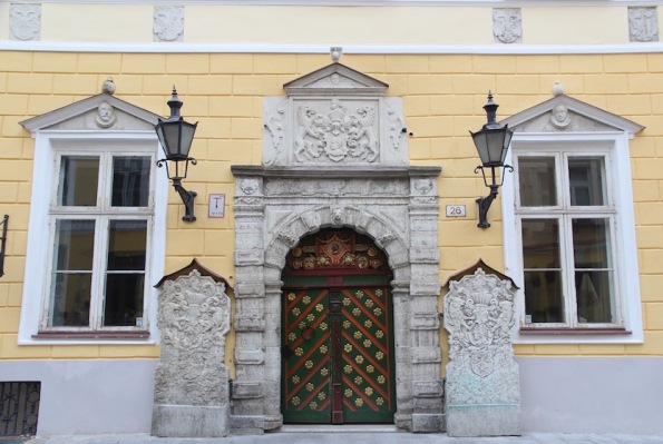
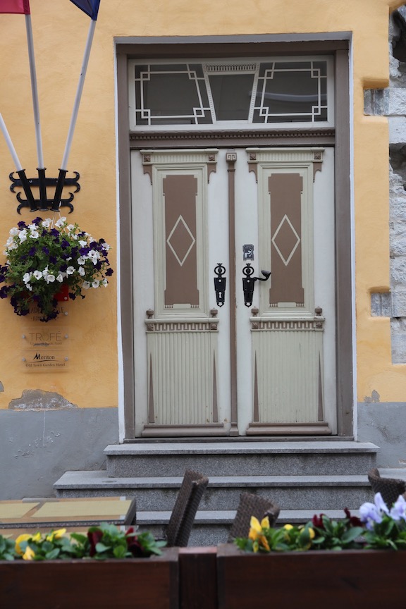
House of the Brotherhood of Black Heads

Close-up of the doorway shown above, House of the Brotherhood of Black Heads


Poor John and I have been lucky enough to visit Tallinn in Estonia twice in recent times. This incredibly beautiful city is home to Gothic spires, winding cobblestone streets and enchanting architecture.
Unlike many other capital cities in Europe, Tallinn has managed to wholly preserve its medieval and Hanseatic origin. Due to its exceptionally intact 13th century inner city plan, the Old Town was named a UNESCO World Heritage Site in 1997.


A walk through Old Town is a feast for the eyes of medieval churches, grand merchant houses, barn and warehouses, many dating back to the Middle Ages.
And of course, all those buildings have doors. That’s what today’s post is about—the magnificent, colourful, intricate and quirky doors of Tallinn. Two doors are captioned. The rest are on homes or businesses.
Do you have a favourite or two or three?


Tallinn City Theatre

Rhodanthe earns an honorary doctorate and comforts a crying baby. Photo by Gary Schafer
Another John in my life (not Poor John) called recently to say Rhodanthe, his wife of 61 years, had died. This was heartbreaking news, but not unexpected. Four days after her death, Rhodanthe would have turned 97, but she’d been failing for some time.
I met Rhodanthe about 15 years ago at the local gym. Yes, the gym! A friend and I went to the gym every Tuesday and Thursday. Our visits always coincided with the Super Seniors gym class. After a couple of years, it made sense to join the class.
Rhodanthe had been part of the class for years, and the exercise (including weights) had served her well. About 10 years ago, she fell and cracked her hip. The doctor said that the gym exercise had built up the muscle around her hip and helped her to heal more quickly than expected.
From the time I first knew her, Rhodanthe always walked from her house to the gym (about 15 minutes), but the time came when macular degeneration robbed her of eyesight and I became her gym chauffeur. I often took her to other appointments.
Rhodanthe and I were on the same page when it came to driving her around. I can still hear many of those conversations.
Me: Rhodanthe would you like a lift to your appointment?
Her John: No, we’ll walk or take the bus.
Me: I didn’t ask you, John? Rhodanthe, would you like a lift?
Rhodanthe: Yes please.
In spite of her deteriorating vision and a general slowing down, Rhodanthe kept coming to the gym until about 18 months ago. All her gym buddies were a bit relieved when she reluctantly agreed to ‘retire’. She had a cavalier attitude to some of the equipment and we lived on tenterhooks, expecting her to fall at any time.
About a year ago, she fell again—at home. The prospects weren’t good. She was in hospital for some time and then in rehab. She wasn’t expected to survive back then. But with support from family, friends, doctors and community nurses, she lasted another year.
But my headline refers to a ‘legendary midwife’. So let me tell you about that aspect of Rhodanthe.

Rhodanthe (right) and Elizabeth (both in their 90s) enjoy morning tea at seniors gym
Rhodanthe, the midwife
Rhodanthe was passionate about new mothers and their babies. In fact, she spent more than 65 years catering for them. It’s calculated that she assisted 23,000 local mothers and their newborns.
She was so concerned about their welfare, that she wrote No one right way—a handbook for parents coping with the first three months of their baby’s life. This book was first published in 2004. It highlights the fact that there is no one right way to raise a baby.
 An updated and revised edition of that book was released in 2012 with the new name of Baby care: nurturing your baby your way.
Rhodanthe specified that royalties from the book should support the education of Aboriginal and Torres Strait Islander midwives. She believed Indigenous women would have improved pregnancy and birth outcomes if their care came from midwives who shared their culture and language. This led to the creation of The Rhodanthe Lipsett Indigenous Midwifery Trust. The trust provides scholarships to Aboriginal and Torres Strait Islanders studying to become midwives. Last year, 14 students received scholarships worth $54,000.
In 2012 and at age 90, Rhodanthe was awarded an honorary doctorate by the University of Canberra for a lifetime of services to baby and maternal health. She was awarded a Medal of the Order of Australia in 1992.
I could go on and on about Rhodanthe, but I’ll leave you with some options to explore. Here’s a link to the news item about her honorary doctorate. Here’s a link to a short history about her life (includes a link to an interview with her).
Memorial service
A memorial service will be held Sunday, 17 February, at St John’s Church Hall, Reid, ACT, at 3pm. In lieu of flowers, the family asks that donations be made to The Rhodanthe Lipsett Indigenous Midwifery Trust.
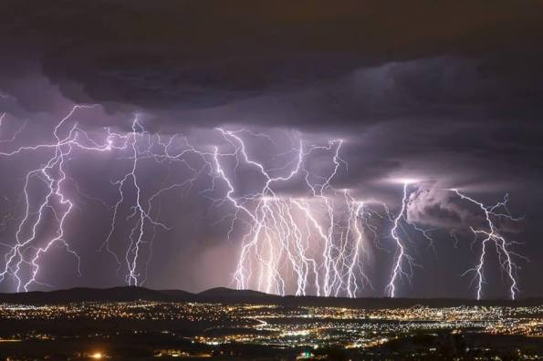
Local photographer Glenn Martin captures the spectacular lightning last night north of Canberra
Indi, our standard schnauzer, may watch television, but she can’t cope with thunder and lightning. She’s not thrilled about fireworks either. We’ve had several noisy thunderstorms over the last 10 days or so. Most have come at night which means she jumps on the bed to be comforted.
Last week I decamped to the single bed in Libby’s room and took the dog with me. Last night she was a wreck, and Poor John decamped to Libby’s room. Indi stayed with me.
Thanks to a post on Facebook, I know what really set her off last night. A bit after midnight, local photographer, Glenn Martin, took himself to the top of Mount Ainslie (not far from our house) to capture about 100 shots of the ‘sound and light’ performance.
Mother Nature sure knows how to put on a show. Martin sure knows how to record it.
P.S. I hadn’t known of Martin’s work before, but you can be sure I’ll follow it now. All of his prints are available for sale.

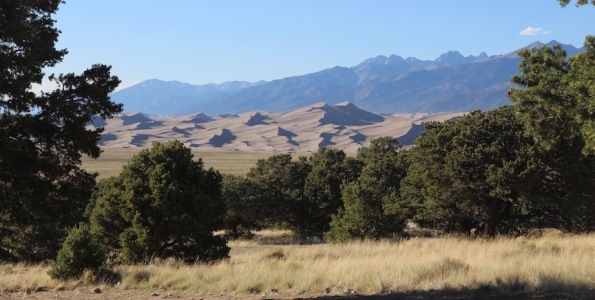
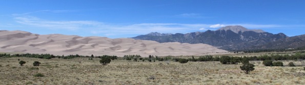
Great Sand Dunes with Sangre de Cristo Mountains in the background. Mt Herard is the tallest
Our recent trip to the beaches at Potato Point reminded me that I haven’t shared all the stops on our recent travels around the western part of the United States.
Not surprisingly, it was the sand at Potato Point that made me think of the Great Sand Dunes National Park and Preserve in south-central Colorado.
First established as a national monument in 1932, the park has the tallest sand dunes in North America—Star Dune rises 755 feet or 230 metres.
Its reclassification to a national park and national preserve in 2004 was driven by the local people’s desire to protect the entire dune system, including the Medano and Sand creeks that run, intermittently, through the area. Initially the monument protected about 35,000 acres, but the expanded park and preserve is now about three times larger.
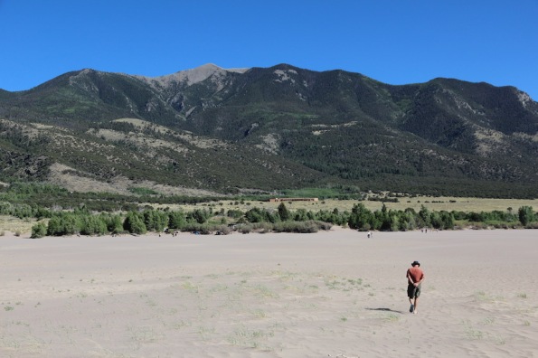
With hands behind his back, Poor John heads back from the dunes
The dunes are believed to be about 440,000 years old and people have inhabited the area for the last 11,000 years.
Most of the sand comes from the San Juan Mountains, 65 miles to the west. The larger, rougher grains and pebbles come from the Sangre de Cristo Mountains, which run through the preserve, but only on the edge of the park.
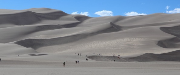
Soon after we arrived, Poor John and I walked across the flat sand to the start of the dunes. There wasn’t any water running in the creeks. It was too late in the afternoon and way too hot to actually carry on up the dunes (many others were ahead of us), but we had a great view of the Sangre de Cristo Mountains.
That evening we put up our tent at a privately-run campground, which is just outside the park. Only a few steps from our tent, there was a fabulous view of the dunes. The campground restaurant wasn’t quite so spectacular. The food was okay, but stone cold when it arrived. That said, we loved visiting the dunes.
The view from near our tent
More about the dunes and sand
I was interested to learn that the park is made up of three distinct parts—the sabkha, the sand sheet and the dunefields.
The sabkha, which is located way beyond where we visited, makes up about one-third of the park. It’s a crusty formation that develops where the water table is very high. It’s an important habitat for migrating birds and other wildlife.
The sand sheet consists of low rolling hills that lie between the sabkha and the dunefields. The grasses and shrubs that grow there help to slow the ‘march’ of the dune.
The dunefields are what we visited. They look barren but support hardy animals and plants, including Indian rice grass and scurfpea.
Approaching the dunefields
A few comments relating to the US government shutdown
According to the park’s website, the dunes will continue to be open 24 hours a day, 7 days a week during the government shutdown. However, the visitor centre and entrance station will remain closed and no visitor services will be available. I bet the campground and restaurant are open.
Also, two articles from The Guardian have caught my eye recently. Both relate to how US national parks are suffering.

Dunes as far as you can see
The first item tells of Dan Little, a retired data expert with the US National Forest Service and husband to Oregon’s governor, Kate Brown. This week, he was so dismayed by the filthy state of the public bathrooms at Mount Hood National Forest’s Sno-Park that he cleaned them himself. I was shocked by the ‘before’ photo that accompanied the article. You’d think, especially under the current circumstances, that people would make an effort to clean up after themselves. It’s not that hard to take your rubbish away with you.
Which leads me to the second item, which appeared in November. That was more than a month before the government shutdown. Even then the article’s authors were explaining the affect people were having on the US national parks—quite simply ‘tourists are loving nature to death’.
Both articles are short and worth a read. I should point out that, like Dan Little in Oregon, hundreds of passionate volunteers are carrying cleanup tasks in many national parks.
Crossing to the dunefield

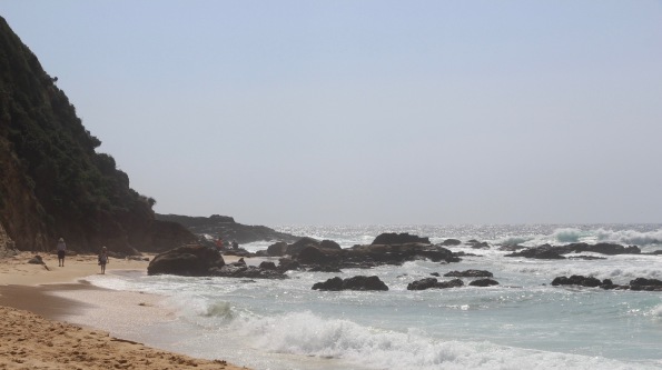
Around the rocks at Potato Point
We’ve had a wonderful week at the beach house, enjoying the company of family and friends. Daughter Libby and son-in-law Daniel came for New Year’s Eve, along with Daniel’s mum and stepdad, Kaye and Elmar from Perth, Western Australia.
Then Derrick and Anne arrived from the UK. A few years back, we travelled with Derrick for two months in South America.
So we thought it was important to show the visitors some great scenery and a good time. Libby and Daniel suggested Potato Point and I had to admit it had been years since I was there.
It was the perfect choice. We started at Jemison’s Beach, known for its rough seas and wild winds. Waves were hammering the beach, expanding an already large sand cliff. It was a reminder that Mother Nature is boss. We walked north along the beach to the actual Potato Point.
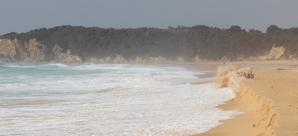
Mother Nature attacks the sand dunes
The village of Potato Point (population about 135) is surrounded by the Eurobodalla National Park. Its name comes from the Brice family. They grew vegetables and potatoes there, and rowed them out to ships standing off the point for transport to the Sydney market.
But the more important and long-lasting history of the area is its connection to the Aborigines. The Yuin are considered to be the traditional owners of the region.
I was moved by a remarkable story written by Noel Perry. It recounts, from an Aboriginal point of view, the 1797 landing by explorer and whaler George Bass. I found it online and can’t see that it is copyrighted, so here it is.
Looking down on Jemison Beach
Aboriginal view of the George Bass landing
‘Travelling south during an expedition which resulted in the discovery of Port Phillip Bay, George Bass stayed overnight at Tuross.
‘On the evening of Saturday, December 16, 1797, his whale boat stood off a point of land which he named Marka Point, the place now known as Potato Point. The next day he landed and walked to what we call Tuross Lake. For someone on his way to test the existence or otherwise of a sea lane between the Pacific and Indian oceans, this break in his journey was but an interlude. He recorded that the area was waterless and empty of human inhabitants.
‘However, to the people whose territory it was, the arrival of a whale boat under sail was a most dramatic event. Fifty years later, when Cooral, an Aboriginal friend, told it to him, a resident of Moruya wrote their version down.
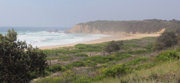
Approaching Potato Point
‘When George Bass and his crew dropped anchor, Cooral, then a young boy, was asleep with his tribe on the cliff above the beach. At dawn, when everybody woke up, they were dismayed to see an enormous white thing just out to sea, its wings spread as if for flight. After a hasty discussion they decided that a monster bird of some unearthly kind had come to pick them up like a hawk does its prey.
‘They fled in terror. They did not stop until they sank exhausted in a gully of the stony creek near what we call Coila. Even there they did not feel safe, for who knew if the great white bird was not hovering above them ready to strike, and they had nothing with which to defend themselves. In their panic they had left all their possessions, all their weapons and their food, behind them on the cliff top. The elders were the first to think beyond fright. They decided that a look-out should be posted to watch the lake and the bravest of the tribe should go back to see what had happened at their camp site.

‘While everyone else crouched in silence, tired and hungry, a courageous little group returned to the sea. Concealing themselves, they paused near the springs and scanned the horizon.There was nothing unusual to see. The monster was no longer there. After much debate they agreed they should walk along the beach to see if the great winged thing had molested their camp site. Creeping cautiously along the high tide mark they bunched together when their leader suddenly stopped.
‘On the sand were unmistakable signs of a canoe of some strange make having been pulled out of the water. Stranger still, there were prints of human feet and beside them others so weird as to be unbelievable. Footprints of two-legged creatures, without toes, prints such as they had never seen before. Despite their fear they tracked the prints of the toeless creatures. But when the prints led towards the place where the tribe was hiding their dread intensified. The one thought that now possessed their minds was that some further horror had come among them. With all speed they hastened back to warn the others.
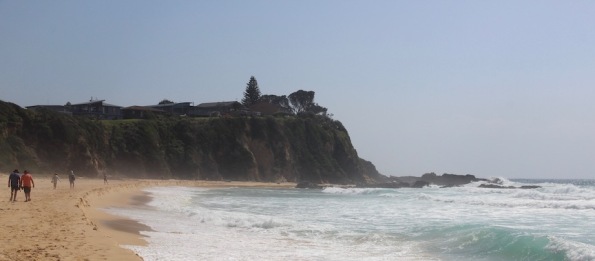
Potato Point looking north

Birds congregate on Potato Point
‘This further news caused more consternation and panic. Not only was the tribe at the mercy of a great bird which might swoop down on them at any moment, but now mysterious toeless beings were coming towards them on land. They spent the day crouched under the trees. At night they huddled together for warmth. They had no fire, no food, no possum rugs to cover themselves and no weapons with which to defend” themselves. It is no wonder that an old man could remember with such detail all that happened during that terrible time. He could not recall how long they stayed there, but at last hunger and cold won over terror. The brave ones once more went back to the camp.

An offending blue bottle. Hope this one didn’t sting anyone
‘At last they reached the campsite. Nothing seemed to have been touched. Food and dilly bags still hung from the trees, weapons and rugs lay about undisturbed. They hastened to tell the others. Slightly reassured but still fearful, the tribe went back. They ate, collected their possessions, and then moved to another place. The big white bird was never seen again and there were no more sightings of toeless footprints. Life gradually returned to normal. By the time Cooral and his peers attained manhood they had heard of similar happenings far to their north and of the coming of the spirits of men, turned white.
‘George Bass had recorded the area as uninhabited. To him it was just one more uneventful day. Yet the memory of that momentous episode, the terror, the courage, so impressed the mind of a young boy that 60 years later he could still remember it in vivid detail.’
P.S. Here’s a pic of a blue bottle (sometimes known as a Portuguese Man ‘o War). The east coast of Australia has been overwhelmed by them this year. There have been 13,000 reported stings in the last two weeks.

Lovely view of Potato Point. Derrick is in the orange t-shirt. Elmar and Kaye are on the right. Photo by Daniel Veryard
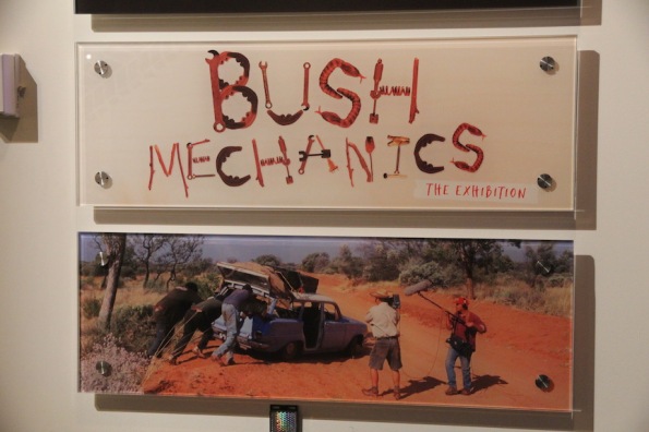
Bush Mechanics

A very battered Holden EJ Special Station Sedan from an early episode (see the clip)
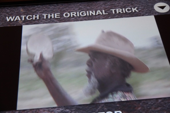
Bush mechanics was one of my favourite Australian-made television programs. First aired in 2001, this clever documentary introduced a nation of mostly white folks to the amazing life, culture, ingenuity and innovation of the Warlpiri people of Yuendumu in Central Australia.
I remember watching the first episode and being totally captivated and impressed. Below is an entertaining clip from that first episode. I can’t figure out how to embed it. Can anyone help on that?
https://www.facebook.com/benngunnfans/videos/318870045618855/
Even though the series hasn’t been aired for many years, this week Poor John and I were able to ‘revisit’ the Bush mechanics at the National Museum of Australia.
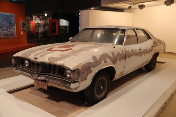
Painted Ford ZF Fairlane
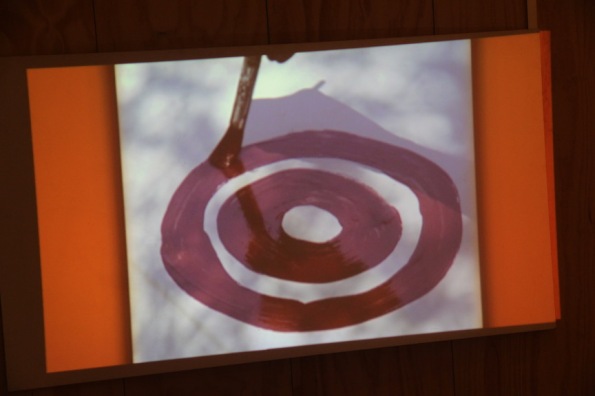
Painting the Ford ZF Fairlane
Painted Ford ZF Fairlane
The exhibition captures the energetic and upbeat tone of the popular TV series created by David Batty and Francis Jupurrurla Kelly. It includes the two cars that are most fondly remembered by fans—the blue Holden EJ Special Station Sedan from an early episode (see the clip above) and the painted Ford ZF Fairlane from the finale.
I still laugh about the stories behind both cars. The Holden was rescued from a junk yard. Thanks to an array of committed efforts, it was rebuilt to carry a local band to their musical gig—293 kilometres away in Willowra.
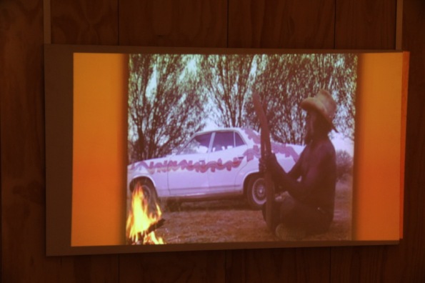
The Ford Fairlane was on another mission. This time to create rain. Thomas Jangala Rice painted the car with a Jukurrpa (creation story) of which he is the custodian.
The bush mechanics drove that car to Broome—1413 kilometres away—to trade it for rainmaking pearl shells. When the shells were returned to Yuendumu, Rice used them to carry out a rainmaking ceremony. The ensuing rains broke a year-long drought.
Thomas Jangala Rice does a rainmaking ceremony
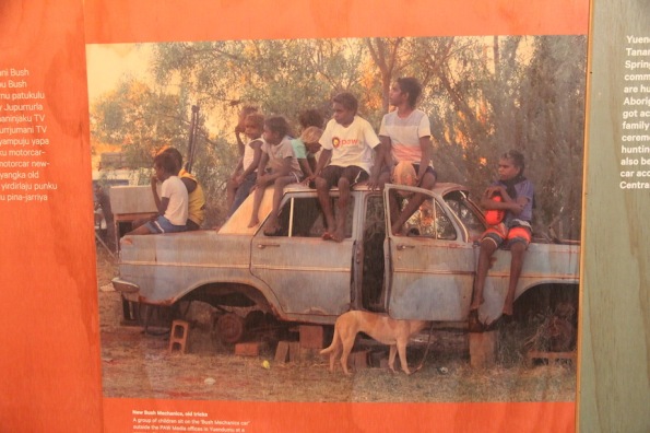
The display also explains the history of bush mechanics. Long before cars were common in the Aussie outback, workers on remote stations across the country had to operate and fix machinery without access to workshops or specialised equipment.
Not surprisingly, many Aboriginal people became talented bush mechanics. When cars arrived in the outback, they quickly adapted their skills to keeping these ‘beasts’ on the road. In the absence of sophisticated tools and spare parts, they used what was to hand, including mulga wood (can be whittled to make brake shoes), sand and spinifex (can be used to stuff a flat tyre).
I’d like to think I could be a little bit of help on one of these expeditions. When Poor John and I lived in Burma (Myanmar) in the early 1980s, I learned quite a bit about keeping a car on the road. For example, I still remember how to blow out a fuel filter so it can be re-used.
Tomorrow’s new bush mechanics
